
Question 21
The map shows regional federal electorates in Victoria.
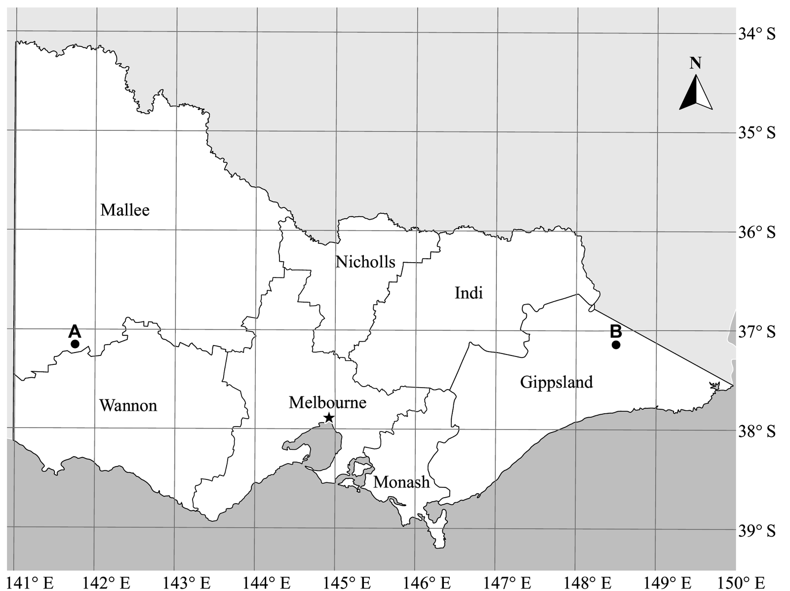
In which federal electorate is the position 37° 10′ S, 146° 30′ E?
[1 mark]Determine the distance between point A in the electorate of Mallee and point B in the electorate of Gippsland along the same parallel of latitude, to the nearest 100 km.
[5 marks]Minutes are sixtieths, and parallels shrink
First, turn the degrees and minutes in part a) into decimals. Then read A and B off the grid, subtract the longitudes, and scale 111.2 km by the cosine of the latitude.
Rounding to the nearest 100 km is generous. Any reading inside the ranges the marking guide accepts still gives 600 km.
Read the map yourself, then test the conversions and the keys
On the left, slide the orange parallel and the two blue meridians until they pass through A and B, and see whether the marking guide would accept your readings. On the right, check part a)’s conversion and part b)’s calculator entry. Each wrong option is an easy slip to make.
Two marks come from reading the map, before any formula
Try each step yourself before you reveal it. Part a) is one mark for the electorate. Part b) has a mark for the latitude, the longitudes, the angle, the substitution and the rounded distance.
Convert the minutes first. There are 60 minutes in a degree.
$$37^\circ\,10'=37+\tfrac{10}{60}\approx37.17^\circ\qquad146^\circ\,30'=146+\tfrac{30}{60}=146.5^\circ$$
So the point is a sixth of the way from 37° S to 38° S, and halfway between 146° E and 147° E. That lands just west of the Gippsland boundary.
A misspelt name still earns the mark.
Marker: correctly identifies the federal electorate
The question says A and B are on the same parallel, and both dots sit just below the 37° S line. Write the latitude down for both points.
$$\text{A and B: }37.25^\circ\text{ S}$$
That is the guide’s reading. Anything from 37.1° S to 37.3° S earns the mark. Measured carefully, the dots are nearer 37.15° S, which is also inside the range. This mark can be implied if the latitude turns up in your substitution.
Marker: correctly identifies the latitude for A and B (37.1° S to 37.3° S)
A is about three quarters of the way from 141° E to 142° E. B is about halfway from 148° E to 149° E.
$$\text{A: }141.75^\circ\text{ E}\qquad\text{B: }148.5^\circ\text{ E}$$
The guide accepts 141.6° E to 141.9° E for A and 148.3° E to 148.7° E for B. Like the latitude, this mark can be implied by your working.
Marker: correctly identifies the longitudes for A (141.6° E to 141.9° E) and B (148.3° E to 148.7° E)
Both longitudes are east, so subtract them.
$$\begin{aligned}\text{Angular distance}&=148.5^\circ-141.75^\circ\\&=6.75^\circ\end{aligned}$$
Follow-through applies from here on, so if your readings were a little off, you can still earn the last three marks by using them correctly.
Marker: determines angular distance
The distance runs east to west along a parallel, so use the same-parallel rule from the formula book. $\theta$ is the latitude, 37.25°.
The rule without the cosine is for two places on the same meridian, due north and south of each other. It doesn’t apply here.
Marker: substitutes values into appropriate rule
Type it in one line with the calculator in degree mode, then round to the nearest 100 km.
$$111.2\cos(37.25^\circ)\times6.75=597.48\ldots$$
597.48 km is not to the nearest 100 km, so it doesn’t finish the job. As a check, 6.75° along the equator would be $111.2\times6.75=750.6$ km, and a parallel at 37.25° S is a smaller circle, so the answer should be less.
Marker: states answer rounded to the nearest 100 km
Each phrase of the question gave you something
A grid to read and one distance rule straight from the formula book. The map does more work than usual, because part b) gives no coordinates. The 2021 subject report asked for more practice at exactly these skills: reading latitude and longitude off a map, choosing the right distance rule, and converting between minutes and decimal degrees.
If I had to guess where you might lose marks, it would be choosing the rule. Leave out the cosine and you get 750.6 km, which rounds to 800 km. In radian mode the right keys give 676 km and round to 700 km, and nothing on the screen warns you. In part a), reading 37° 10′ as 37.10° is the slip to watch for. It happens to land in Indi here, which is luck rather than method.
Only mark this done when you could do it without help. Reading the solution does not count.
Question wording and marking-guide steps are from the 2021 QCAA General Mathematics external assessment, © State of Queensland (QCAA) 2021, licensed under CC BY 4.0, and have been adapted. Tangent Tuition is not affiliated with the QCAA.
Spot a mistake on this page? Report it